Bestand:MapCalifornia.PNG
Naar navigatie springen
Naar zoeken springen


Grootte van deze voorvertoning: 710 × 599 pixels. Andere resoluties: 284 × 240 pixels | 569 × 480 pixels | 788 × 665 pixels.
Afbeelding in hogere resolutie (788 × 665 pixels, bestandsgrootte: 272 kB, MIME-type: image/png)

|
Deze afbeelding is naar Wikimedia Commons verplaatst van wts.oldwikivoyage met behulp van een bot. Alle broninformatie is nog aanwezig, maar dit moet nagekeken worden. Er kunnen fouten zitten in de verschillende informatievelden. Kijk deze afbeelding na, pas eventueel wat aan en verwijder daarna dit sjabloon. Kijk nu na! |
Beschrijving
| Beschrijving |
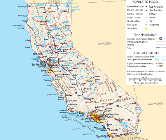
English: Location of California. This maps shows the location of California in the continental U.S. The map is based of public domain materials from a U.S. government agency., California
|
| Datum | |
| Bron | |
| Auteur | (WT-en) Sapphire |
Licentie
Dit bestand is gelicenseerd onder de Creative Commons-licentie Naamsvermelding-Gelijk delen 1.0 Unported
- De gebruiker mag:
- Delen – het werk kopiëren, verspreiden en doorgeven
- Remixen – afgeleide werken maken
- Onder de volgende voorwaarden:
- naamsvermelding – U moet op een gepaste manier aan naamsvermelding doen, een link naar de licentie geven, en aangeven of er wijzigingen in het werk zijn aangebracht. U mag dit op elke redelijke manier doen, maar niet zodanig dat de indruk wordt gewekt dat de licentiegever instemt met uw werk of uw gebruik van zijn werk.
- Gelijk delen – If you alter, transform, or build upon this work, you must distribute the resulting work under the same license as the original.
Oorspronkelijk uploadlogboek
| This file was imported from Wikivoyage WTS. |
De oorspronkelijke beschrijving van deze afbeelding stond hier. Alle volgende gebruikersnamen verwijzen naar wts.wikivoyage-old.
- 2007-02-09 05:58 (WT-shared) Sapphire[dead link] 788×665 (278863 bytes) {{Imagecredit |credit=[[:en:User:Sapphire|Sapphire]] |captureDate=February 7, 2007 |location=California |source= |caption=Location of Califo (Import from wikitravel.org/shared)
Bestandsgeschiedenis
Klik op een datum/tijd om het bestand te zien zoals het destijds was.
| Datum/tijd | Miniatuur | Afmetingen | Gebruiker | Opmerking | |
|---|---|---|---|---|---|
| huidige versie | 18 nov 2012 03:16 | | 788 × 665 (272 kB) | MGA73bot2 | {{BotMoveToCommons|wts.oldwikivoyage|year={{subst:CURRENTYEAR}}|month={{subst:CURRENTMONTHNAME}}|day={{subst:CURRENTDAY}}}} == {{int:filedesc}} == {{Information |description=Location of California. This maps shows the location of California in the cont... |
Bestandsgebruik
Dit bestand wordt op de volgende pagina gebruikt: