Bestand:Kft B-L 1789.png
Naar navigatie springen
Naar zoeken springen

Grootte van deze voorvertoning: 631 × 600 pixels. Andere resoluties: 253 × 240 pixels | 505 × 480 pixels | 787 × 748 pixels.
Afbeelding in hogere resolutie (787 × 748 pixels, bestandsgrootte: 440 kB, MIME-type: image/png)
| Beschrijving |
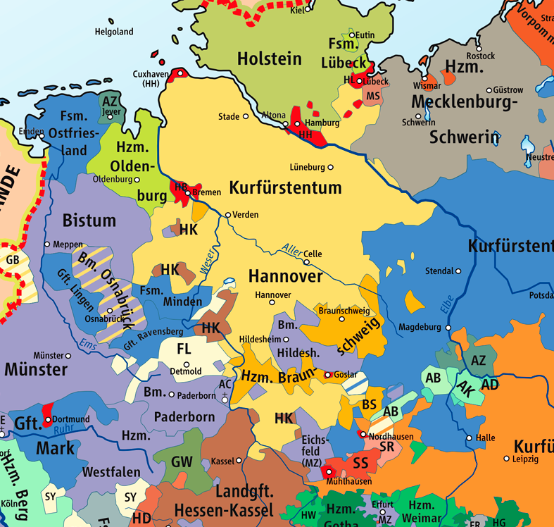
Karte des Kurfürstentums Braunschweig-Lüneburg 1789 / Map of the Electorate of Brunswick-Lüneburg 1789, Ausschnitt aus : |
||
| Datum | |||
| Bron | Wikipedia/Source of Information: Putzger – Historischer Weltatlas, 89. Auflage, 1965 | ||
| Auteur | kgberger | ||
| Toestemming (Hergebruik van dit bestand) |
GNU Free Documentation License | ||
| Andere versies |
|


|
Toestemming wordt verleend voor het kopiëren, verspreiden en/of wijzigen van dit document onder de voorwaarden van de GNU-licentie voor vrije documentatie, versie 1.2 of enige latere versie als gepubliceerd door de Free Software Foundation; zonder Invariant Sections, zonder Front-Cover Texts, en zonder Back-Cover Texts. Een kopie van de licentie is opgenomen in de sectie GNU-licentie voor vrije documentatie. |
| Dit bestand is gelicenseerd onder de Creative Commons-licentie Naamsvermelding-Gelijk delen 3.0 Unported | ||
| ||
| Deze licentietag is toegevoegd aan dit bestand in verband met de GFDL licentie-update. |
Bestandsgeschiedenis
Klik op een datum/tijd om het bestand te zien zoals het destijds was.
| Datum/tijd | Miniatuur | Afmetingen | Gebruiker | Opmerking | |
|---|---|---|---|---|---|
| huidige versie | 8 nov 2008 23:22 | | 787 × 748 (440 kB) | Papa01~commonswiki | {{Information |Description=Karte des Kurfürstentums Braunschweig-Lüneburg 1789 / Map of the Electorate of Brunswick-Lüneburg 1789 |Source=Wikipedia/Source of Information: Putzger – Historischer Weltatlas, 89. Auflage, 1965 |Date=2007-02-25 |Author=k |
Bestandsgebruik
Dit bestand wordt op de volgende 2 pagina's gebruikt: