Bestand:West Mediterranean areas 306BC-fr.svg
Naar navigatie springen
Naar zoeken springen


Afmetingen van deze voorvertoning van het type PNG van dit SVG-bestand: 800 × 402 pixels Andere resoluties: 320 × 161 pixels | 640 × 322 pixels | 1.024 × 515 pixels | 1.280 × 643 pixels | 812 × 408 pixels.
Afbeelding in hogere resolutie (SVG-bestand, nominaal 812 × 408 pixels, bestandsgrootte: 1,12 MB)
| Beschrijving |
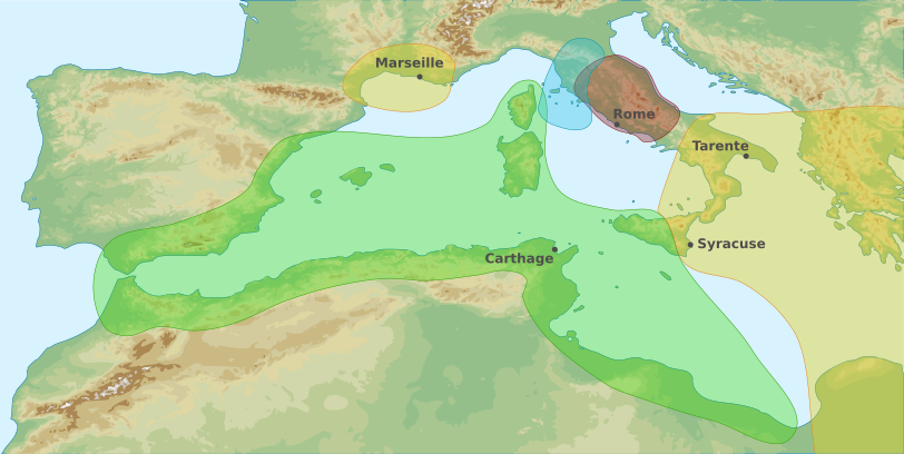
English: Map of area of influences in the Western Mediterranean Sea in 306 BC Français : Carte des zones d'influences dans l'Ouest de la Mer Méditerranée en 306 av. J-C Carthaginois Étrusques Grecs Romains |
| Datum | (UTC) |
| Bron | |
| Auteur |
|
| Andere versies |
|
-fr.svg)

Français : Cette carte a été créée par Pethrus d'après les sources mentionnés ci-dessus. Il s'agit d'un travail d'amateur, même s'il a été réalisé avec soin ; il peut comporter des inexactitudes ou des erreurs. Cette carte a donc un rôle d'illustration et non de référence. N'hésitez pas à me signaler toute erreur que vous constateriez ou à effectuer vous-même la correction. English: This map was drawn by Pethrus from sources mentionned above. Even if it was done with care, this is an amateur work ; there might be some inaccuracies or errors. As such, it should not be considered authoritative. Please contact me if you notice any mistake, and feel free to correct it yourself.
|

|
Dit SVG-bestand maakt gebruik van geïntegreerde tekst die gemakkelijk kan worden vertaald naar uw taal met een SVG editor, een tekstverwerker of het hulpmiddel SVG Translate. Uitleg |
Ik, de auteursrechthebbende van dit werk, maak het hierbij onder de volgende licenties beschikbaar:
Dit bestand is gelicenseerd onder de Creative Commons-licenties Naamsvermelding-Gelijk delen 3.0 Unported, 2.5 Algemeen, 2.0 Algemeen en 1.0 Algemeen.
- De gebruiker mag:
- Delen – het werk kopiëren, verspreiden en doorgeven
- Remixen – afgeleide werken maken
- Onder de volgende voorwaarden:
- naamsvermelding – U moet op een gepaste manier aan naamsvermelding doen, een link naar de licentie geven, en aangeven of er wijzigingen in het werk zijn aangebracht. U mag dit op elke redelijke manier doen, maar niet zodanig dat de indruk wordt gewekt dat de licentiegever instemt met uw werk of uw gebruik van zijn werk.
- Gelijk delen – Als u het werk heeft geremixt, veranderd, of erop heeft voortgebouwd, moet u het gewijzigde materiaal verspreiden onder dezelfde licentie als het oorspronkelijke werk, of een daarmee compatibele licentie.

|
Toestemming wordt verleend voor het kopiëren, verspreiden en/of wijzigen van dit document onder de voorwaarden van de GNU-licentie voor vrije documentatie, versie 1.2 of enige latere versie als gepubliceerd door de Free Software Foundation; zonder Invariant Sections, zonder Front-Cover Texts, en zonder Back-Cover Texts. Een kopie van de licentie is opgenomen in de sectie GNU-licentie voor vrije documentatie. |
U mag zelf één van de licenties kiezen.
Oorspronkelijk uploadlogboek
This image is a derivative work of the following images:
- File:West_Mediterranean_Areas_306_BC.png licensed with PD-user
- 2006-07-14T09:25:32Z Horatius 1340x937 (2162275 Bytes) == Summary == Main areas of influence in West Mediterranean Sea in 306 BC. Principali aree di influenza nel Mediterraneo Occidentale nell'anno 306 aC (Terzo Trattato Roma-Cartagine). == Licensing == {{PD-user|Horatius}}
- File:West_Mediterranean_sea_topographic_map.svg licensed with Cc-by-sa-3.0,2.5,2.0,1.0, GFDL
- 2010-03-23T22:50:18Z Pethrus 812x408 (1161860 Bytes) {{Information |Description={{en|1=Topographic map of Western Mediterranean Sea}}{{fr|1=Carte topographique de l'Ouest de la Mer Méditerranée}} |Source=*[[:File:Western_Europe_DEMIS_topographic_map.svg|]], a DEMIS map {{inks
Uploaded with derivativeFX
Bestandsgeschiedenis
Klik op een datum/tijd om het bestand te zien zoals het destijds was.
| Datum/tijd | Miniatuur | Afmetingen | Gebruiker | Opmerking | |
|---|---|---|---|---|---|
| huidige versie | 24 mrt 2010 23:16 | | 812 × 408 (1,12 MB) | Pethrus | {{Information |Description={{en|1=Map of area of influences in the Western Mediterranean Sea in 306 BC}}{{fr|1=Carte des zones d'influences dans l'Ouest de la Mer Méditerranée en 306 av. J-C {{legend|#A3EBA9|Carthaginois}}{{legend|#9BE1F5|Étrusques}}{{ |
Bestandsgebruik
Dit bestand wordt op de volgende pagina gebruikt: