Bestand:Satelite image of Malta.jpg

Uit Wikikids
Naar navigatie springen Naar zoeken springen

Afbeelding in hogere resolutie(2.760 × 2.124 pixels, bestandsgrootte: 723 kB, MIME-type: image/jpeg)

Dit bestand is afkomstig van Wikimedia Commons en kan ook in andere projecten gebruikt worden. De bestandsbeschrijvingspagina wordt hieronder weergegeven.

Beschrijving

Beschrijving
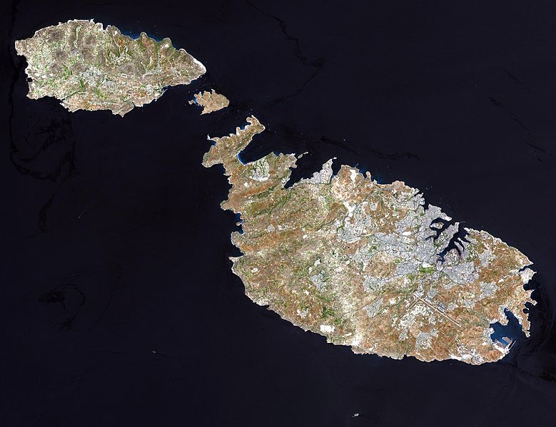
English: Malta, an independent republic, consists of a small group of islands—Malta, Gozo, Kemmuna, Kemmunett, and Filfla—located in the Mediterranean Sea south of Sicily, with a total area of 316 square kilometers. The capital and leading port of the country is Valletta, which appears as a gray patch around the two deep inlets on Malta’s northern coastline. About 400,000 people live on this island nation. The islands of Malta consist of low-lying coralline limestone plateaus surrounded by impermeable clay slopes. The highest point is 239 meters above sea level.

The many ancient monuments and remains on Malta attest to the great age of its civilization. Remains from Stone Age and Bronze Age peoples have been found in subterranean burial chambers. The islands became a Phoenician colony about 1000 B.C. They were later occupied by the Greeks, who called the colony Melita, and later the islands passed successively into the possession of Carthage and Rome. The islands were occupied by Arabs in 870 A.D. A Norman army conquered the Maltese Arabs in 1090, and Malta was later made a feudal fief of the kingdom of Sicily. In 1530 Holy Roman Emperor Charles V granted Malta to the Knights of Saint John of Jerusalem, who ruled the islands until the 19th century. In 1798 Napoleon invaded and occupied the islands during his Egyptian campaign. Unwilling to be ruled by France, the Maltese appealed to Britain, and in 1799 British naval officer Horatio Nelson besieged Valletta and compelled the withdrawal of the French. In 1814 Malta became part of the British Empire as a crown colony.

This natural-color image was acquired on July 29, 2001, by the Advanced Spaceborne Thermal Emission and Reflection Radiometer (ASTER) aboard NASA’s Terra satellite.

Image courtesy NASA/GSFC/MITI/ERSDAC/JAROS, and U.S./Japan ASTER Science Team
Bron

http://earthobservatory.nasa.gov/Newsroom/NewImages/images.php3?img_id=16706 NASA]


Public domain Dit bestand bevindt zich in het publiek domein, omdat het gemaakt is door de NASA. In de reproductierichtlijnen van de NASA staat dat "NASA-materiaal niet beschermd wordt door auteursrecht, tenzij anders vermeld".

(NASA copyright policy page of JPL Image Use Policy).

Waarschuwingen:
  • Het gebruik van logo's, insignes en emblemen van de NASA wordt beperkt door de Amerikaanse wet 14 CFR 1221.
  • Op de website van de NASA staat een groot aantal afbeeldingen van het Sovjet-/Russisch ruimteagentschap en andere niet-Amerikaanse ruimteagentschappen. Deze afbeeldingen bevinden zich niet noodzakelijk in het publieke domein.
  • Materiaal dat gebaseerd is op gegevens van de ruimtetelescoop Hubble wordt mogelijk beschermd door auteursrecht als dit niet expliciet vervaardigd is door het STScI [1]. Zie tevens {{PD-Hubble}} en {{Cc-Hubble}} of {{Spacetelescope.org}}.
  • Het gemeenschappelijk project van ESA en NASA betreffende de ruimtesonde SOHO suggereert dat al het materiaal dat gemaakt is door zijn ruimtesonde beschermd wordt door auteursrecht en dat toestemming vereist is voor commercieel niet-educatief gebruik. [2]
  • Afbeeldingen op de Astronomy Picture of the Day-website (APOD) worden mogelijk beschermd door auteursrecht. [3]
Auteur

derivative works

Afgeleide werken van dit bestand:  Archipel maltais.jpg

Bestandsgeschiedenis

Klik op een datum/tijd om het bestand te zien zoals het destijds was.

Datum/tijdMiniatuurAfmetingenGebruikerOpmerking
huidige versie24 dec 2004 06:05Miniatuurafbeelding voor de versie van 24 dec 2004 06:052.760 × 2.124 (723 kB)Chris 73

Dit bestand wordt op de volgende pagina gebruikt:

Afkomstig van Wikikids , de interactieve Nederlandstalige Internet-encyclopedie voor en door kinderen. "https://wikikids.nl/Bestand:Satelite_image_of_Malta.jpg"