Bestand:National-atlas-vermont.png
Naar navigatie springen
Naar zoeken springen
Geen hogere resolutie beschikbaar.
National-atlas-vermont.png (763 × 586 pixels, bestandsgrootte: 82 kB, MIME-type: image/png)
Transwiki approved by: w:en:User:Dmcdevit
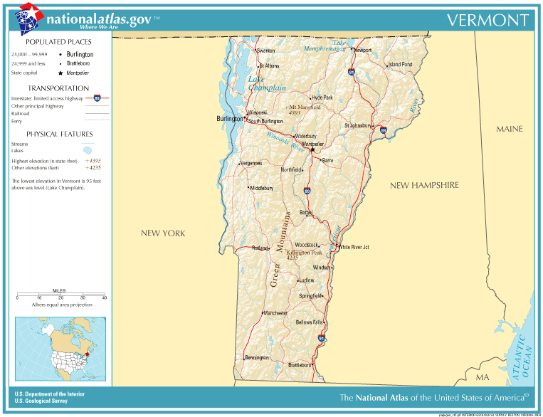
This image was copied from wikipedia:en. The original description was:
This map was obtained from an edition of the National Atlas of the United States. Like almost all works of the U.S. federal government, works from the National Atlas are in the public domain in the United States.
Online access: NationalAtlas.gov | 1970 print edition: Library of Congress, Perry-Castañeda Library
|
Oorspronkelijk uploadlogboek
| date/time | username | resolution | size | edit summary |
|---|---|---|---|---|
| 11:34, 13 December 2004 | w:en:User:Berkut | 763×586 | 82 KB | reduced file size |
| 20:26, 4 November 2004 | w:en:User:Jengod | 763×586 | 223 KB | {{PD-USGov}} <a href="/wiki/Category:Vermont_maps" title="Category:Vermont maps">Category:Vermont maps</a> |
Image description page history
| link | date/time | username | edit summary |
|---|---|---|---|
| http://en.wikipedia.org/w/index.php?title=Image:National-atlas-vermont.png&redirect=no&oldid=69888965 | 07:09, 10 September 2007 | w:en:User:Dmcdevit | |
| http://en.wikipedia.org/w/index.php?title=Image:National-atlas-vermont.png&redirect=no&oldid=69888965 | 21:18, 15 August 2006 | w:en:User:Neutrality | |
| http://en.wikipedia.org/w/index.php?title=Image:National-atlas-vermont.png&redirect=no&oldid=16895586 | 22:21, 30 November 2004 | w:en:User:Jengod | |
| http://en.wikipedia.org/w/index.php?title=Image:National-atlas-vermont.png&redirect=no&oldid=7996400 | 20:26, 4 November 2004 | w:en:User:Jengod | ({{PD-USGov}} <a href="/wiki/Category:Vermont_maps" title="Category:Vermont maps">Category:Vermont maps</a>) |
Bestandsgeschiedenis
Klik op een datum/tijd om het bestand te zien zoals het destijds was.
| Datum/tijd | Miniatuur | Afmetingen | Gebruiker | Opmerking | |
|---|---|---|---|---|---|
| huidige versie | 10 sep 2007 18:02 | | 763 × 586 (82 kB) | BetacommandBot | Transwiki approved by: w:en:User:Dmcdevit This image was copied from wikipedia:en. The original description was: {{PD-USGov-Atlas}} w:en:Category:Vermont maps === File history === {| class=wikitable ! date/time || username || resolution || siz |
Bestandsgebruik
Dit bestand wordt op de volgende pagina gebruikt: