Bestand:JNA offensive plan 1991.jpg
Naar navigatie springen
Naar zoeken springen

Grootte van deze voorvertoning: 582 × 600 pixels. Andere resoluties: 233 × 240 pixels | 466 × 480 pixels | 651 × 671 pixels.
Afbeelding in hogere resolutie (651 × 671 pixels, bestandsgrootte: 426 kB, MIME-type: image/jpeg)

|
Bestand:JNA offensive plan 1991 - ru.svg is een vectorversie van dit bestand. Indien niet van slechtere kwaliteit dient deze gebruikt te worden in plaats van deze rasterafbeelding.
File:JNA offensive plan 1991.jpg → File:JNA offensive plan 1991 - ru.svg
Zie Help:SVG voor meer informatie. |
 |

|
Deze kaartafbeelding zou opnieuw moeten worden aangemaakt als een SVG-bestand door vectorafbeeldingen te gebruiken. Dit heeft een aantal voordelen; zie Commons:Media for cleanup voor meer informatie. Als er een SVG-formaat van deze afbeelding bestaat, dan deze graag uploaden. Nadat u dit heeft gedaan, gelieve dit sjabloon te vervangen door het sjabloon {{vector version available|nieuwe bestandsnaam.svg}} op deze afbeeldingspagina.
|


Beschrijving
| Beschrijving |
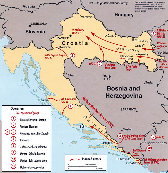
English: Strategic offensive plan of the Yugoslav People's Army in Croatia, 1991; map's caption states "DI Cartography Center 753545AI (R00446) 8-01" |
| Datum | 16 January 2006 (originele uploaddatum) |
| Bron | Central Intelligence Agency Office of Russian and European Analysis (2002) "Map F - JNA Strategic Offensive Plan, 1991" in Balkan Battlegrounds: A Military History of the Yugoslav Conflict, 1990–1995 Volume I, Washington, DC: Central Intelligence Agency ISBN: 9780160664724. ISBN 9780160664724 / map source: File:Kroatien - Politische Gliederung (Karte).svg by Maximilian Dörrbecker |
| Auteur | Central Intelligence Agency |
| Andere versies |
|

.svg)
| This image is a work of a Central Intelligence Agency employee, taken or made as part of that person's official duties. As a Work of the United States Government, this image or media is in the public domain in the United States.
|

|
Bestandsgeschiedenis
Klik op een datum/tijd om het bestand te zien zoals het destijds was.
| Datum/tijd | Miniatuur | Afmetingen | Gebruiker | Opmerking | |
|---|---|---|---|---|---|
| huidige versie | 7 feb 2011 15:39 | | 651 × 671 (426 kB) | DIREKTOR | Rm border |
Bestandsgebruik
Dit bestand wordt op de volgende pagina gebruikt: