Bestand:5 Boroughs Labels New York City Map.svg
Naar navigatie springen
Naar zoeken springen


Afmetingen van deze voorvertoning van het type PNG van dit SVG-bestand: 606 × 599 pixels Andere resoluties: 243 × 240 pixels | 485 × 480 pixels | 607 × 600 pixels | 777 × 768 pixels | 1.035 × 1.024 pixels | 2.000 × 1.978 pixels.
Afbeelding in hogere resolutie (SVG-bestand, nominaal 2.000 × 1.978 pixels, bestandsgrootte: 138 kB)
Beschrijving
| Beschrijving |
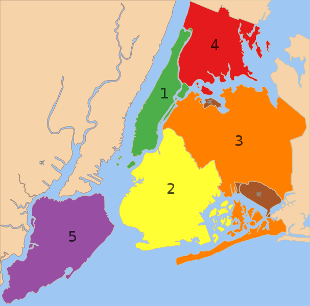
A map showing the five boroughs of New York City, as well as airports. 1. Manhattan
2. Brooklyn
3. Queens
4. Bronx
5. Staten Island
Airports: North East: LGA; South East: JFK; West: EWR |
| Datum | |
| Bron |
 |
| Auteur |
|
| Andere versies |
 |
Licentie
| Dit werk vrijgegeven in het publieke domein door de auteur, Nafsadh. Dit is wereldwijd van toepassing. In sommige landen is dit wettelijk niet mogelijk; in die gevallen geldt: |
Bestandsgeschiedenis
Klik op een datum/tijd om het bestand te zien zoals het destijds was.
| Datum/tijd | Miniatuur | Afmetingen | Gebruiker | Opmerking | |
|---|---|---|---|---|---|
| huidige versie | 10 feb 2023 00:57 | | 2.000 × 1.978 (138 kB) | Nafsadh | Reverted to version as of 18:55, 26 October 2014 (UTC) Intention to not add English label to the svg itself was to keep it mostly language independent and not having to be subject to svg text rendering issues. |
Bestandsgebruik
Dit bestand wordt op de volgende pagina gebruikt: