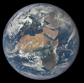
Bestand:Africa and Europe from a Million Miles Away.png

Afbeelding in hogere resolutie (1.780 × 1.768 pixels, bestandsgrootte: 3,68 MB, MIME-type: image/png)
Dit bestand is afkomstig van Wikimedia Commons en kan ook in andere projecten gebruikt worden. De bestandsbeschrijvingspagina wordt hieronder weergegeven.
Beschrijving
| BeschrijvingAfrica and Europe from a Million Miles Away.png |
العربية: صُورة لِأوروپَّا وأفريقيا التقطتها كاميرا مرصد مناخ الفضاء العميق التابع لِوكالة ناسا يوم 29 تمُّوز (يوليو) 2015م.
English: July 29, 2015
Africa and Europe from a Million Miles Away http://www.nasa.gov/image-feature/africa-and-europe-from-a-million-miles-away Africa is front and center in this image of Earth taken by a NASA camera on the Deep Space Climate Observatory (DSCOVR) satellite. The image, taken July 6 from a vantage point one million miles from Earth, was one of the first taken by NASA’s Earth Polychromatic Imaging Camera (EPIC). Central Europe is toward the top of the image with the Sahara Desert to the south, showing the Nile River flowing to the Mediterranean Sea through Egypt. The photographic-quality color image was generated by combining three separate images of the entire Earth taken a few minutes apart. The camera takes a series of 10 images using different narrowband filters -- from ultraviolet to near infrared -- to produce a variety of science products. The red, green and blue channel images are used in these Earth images. The DSCOVR mission is a partnership between NASA, the National Oceanic and Atmospheric Administration (NOAA) and the U.S. Air Force, with the primary objective to maintain the nation’s real-time solar wind monitoring capabilities, which are critical to the accuracy and lead time of space weather alerts and forecasts from NOAA. DSCOVR was launched in February to its planned orbit at the first Lagrange point or L1, about one million miles from Earth toward the sun. It’s from that unique vantage point that the EPIC instrument is acquiring images of the entire sunlit face of Earth. Data from EPIC will be used to measure ozone and aerosol levels in Earth’s atmosphere, cloud height, vegetation properties and a variety of other features.Português: A África é vista no centro desta imagem da Terra tirada pelo satélite DSCOVR. A imagem, obtida em 6 de julho de 2015 de um ponto a 1,6 milhão de quilômetros da Terra, foi uma das primeiras captadas pela câmera EPIC (Earth Polychromatic Imaging Camera) da NASA.
తెలుగు: పది లక్షల మైళ్ళ దూరం నుండి ఆఫ్రికా, ఐరోపా. |
| Datum | |
| Bron | NASA |
| Auteur | NASA |
|

|
Deze afbeelding is geselecteerd als afbeelding van de dag op 6 december 2015. De afbeelding heeft de volgende beschrijving: Andere talen:
Deutsch: Die Erde, fotografiert aus einer Höhe von 1,6 Millionen Kilometern. Auf dem Bild sind die Kontinente Europa und Afrika zu sehen. Português: A África é vista no centro desta imagem da Terra tirada pelo satélite DSCOVR. A imagem, obtida em 6 de julho de 2015 de um ponto a 1,6 milhão de quilômetros da Terra, foi uma das primeiras captadas pela câmera EPIC (Earth Polychromatic Imaging Camera) da NASA. 中文: 百万英里外的非洲和欧洲。 中文(繁體): 百萬英里外的非洲和歐洲。 |

|
This image was selected as picture of the day on Vietnamese Wikipedia.
|
Licentie
| Public domainPublic domainfalsefalse |
| Dit bestand bevindt zich in het publiek domein, omdat het gemaakt is door de NASA. In de reproductierichtlijnen van de NASA staat dat "NASA-materiaal niet beschermd wordt door auteursrecht, tenzij anders vermeld". |  | |
 |
Waarschuwingen:
|
Bijschriften
29 jul 2015
image/png
ab3754ac84034af20df9bebde8988171e7657e96
3.858.262 byte
1.768 pixel
1.780 pixel
Bestandsgeschiedenis
Klik op een datum/tijd om het bestand te zien zoals het destijds was.
| Datum/tijd | Miniatuur | Afmetingen | Gebruiker | Opmerking | |
|---|---|---|---|---|---|
| huidige versie | 9 aug 2015 14:09 |  | 1.780 × 1.768 (3,68 MB) | JorisvS | crop; there was too much black |
Bestandsgebruik
Dit bestand wordt op de volgende pagina gebruikt:
Metadata
Dit bestand bevat aanvullende gegevens, die waarschijnlijk door een fotocamera, scanner of fotobewerkingsprogramma toegevoegd zijn.
Als het bestand is aangepast, komen sommige details mogelijk niet overeen met het gewijzigde bestand.
| Horizontale resolutie | 37,8 dpc |
|---|---|
| Verticale resolutie | 37,8 dpc |
| Tijdstip laatste bestands wijzigingen | 10 jul 2015 02:06 |